Way back on 19th July, I posted a blog on a visit to our woods by an expert forestier from the Centre Régional de la Propriété Forestière (CRPF). This department offer advice to the owners of woodlands on how best to manage them, what financial aid might be available and on any regulations applicable. They also administer the certification for sustainable wood, Programme Européen des Forêts Certifiées , which apparently is similar to FSC certification. One issue that was raised by Monsieur Girard was that if the original owner had had a state subsidy to plant, it could place restrictions on how the wood is managed, which would affect our own permaculture ambitions for the wood.
I’ve recently had another expert forestier from a different department, the Direction Départementale de l'Agriculture et de la Forêt (DDAF). The DDAF have a more general role in agriculture and also act in a regulatory role, enforcing directions and legislation. They work cooperatively with the CRPF and, helpfully for me, both expert foresters know each other well. Considering he works for a state department, in a regulatory role, and our wood is comparatively so small, I was particularly impressed with how helpful and ecologically spot-on he was. He spent over two hours walking the wood with me, was very receptive to our permaculture ideas for managing the woods while also offering advice and a practical exercise in how to choose trees for keeping and the felling pattern for those surrounding them.
He said that the original owner had received bad advice on what species to plant and no management at all had taken place since planting. The original file has disappeared and so the only restriction for us is that we can't cut all the trees down and change the use of the land, i.e., it must remain woodland. He suggested that we could possibly arrange a third meeting with both experts present and, in the meantime, I must come up with a management plan to discuss with them on site. The first part of this process is drawing a base map. Over such a large area, where the trees made it nigh on impossible to pace out distances in a straight line or visually join up different parts of it, this is one job (like all the base-mapping, in fact!) that I’d left. The not-particularly-ecological-easily-impressed-with-gadgets boy in me had thoughts of buying a GPS finder and plotting landmarks on a large sheet of squared paper but I received advice that the leisure models available for the money I was prepared to pay would be nowhere near accurate enough for mapping and would be further compromised by the tree canopy obscuring the sky and therefore satellite.
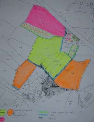
This advice has saved me money, as when I started mapping, it all made sense rather quickly. The land used to be pasture separated by hedgerow with trees, the French term is bocage. These dividing trees are mainly beech, for some reason, and some of them remain and others that have been cut to the stump have re-grown coppice-fashion. These lines of old beech correspond to the numbered parcels marked on the carte cadastrale (land registry map). The previous owner has planted up whole parcels with single species, so it has been relatively easy to produce a helpful map, see photo above.
